Sunday, March 25, 2012

Mile 342 to 347


Some of the "Mormon Rocks" along the hike.
The Mormons settled San Bernardino and this area --
hence the name.
Section D
I-15 to Swarthout Canyon Road – Sobo
Miles: 5
Hiking with: Chris, Gary B & Rob


Lodging:  Holiday Inn Express, Hesperia, CA  - There are a lot of hotels in Hesperia. There are a lot of hotels in the area and at the next intersection to the north & a lot of restaurants.  I booked through www.hotwire.com and paid about $80.

Shuttle: I bought a Dual Sport Bike (Kawasaki 250) on the back of Gary's new Ford F-150 King Cab pick up truck....sweet.


Dining: On the way back to Phoenix we stopped at Crazy Coyote Tacos a taco stand off of I-10 (don't mind some of the mediocre comments left on Yelp -- these are great Tacos).  I had the Giant Taco -- Excellent!!!  This was featured on the Travel Channel by Anthony Bourdain.  Excellent food!!!  It is on the west side of the Cabazon Outlet Shops on the frontage road -- you can't miss it!!!

Start: We took Lone Pine Canyon Road off of Hwy 136 just west of I-15.  Just after the big right hand bend in Lone Pine Canyon Road turn left onto Swarthout Canyon Road (a flat well maintained dirt road).  

End: I-15 just south of the McDonald's.

People along the trail: We saw no one on the trail.


Description: We dropped off my motor bike at the end of the road just south of the I-15 McDonald's at Cajon Pass.  I chained it to the telephone pole.  We then drove about 20 minutes to the trail head at Swarthout Canyon Road.  There was no parking at the PCT crossing but there are several spots to pull of the side of the road within 200 yards.

OK -- I thought this would be an ordinary hike simply going around a small mountain and then going through the Mohave River bed next to I-15 and then going under I-15 to the end.  Was I ever wrong!!!  This was a fantastic 5 miles!!!  The first mile you hike along some mountains and then wow!!!  First you start hiking along the ridge of very steep cliffs (Gary is afraid of heights -- oops), then you hike along some boulders, then you drop down into a pretty desert patch with long horn cactus, than you cross a train track, go through a huge conduit under another train track, hike around an old dumpy home (there was a historic marker in their yard -- who knows), then you go through cottonwood trees, under the huge I-15 underpass that has water running through it.  This could have been the best 5 miles so far on the PCT (although it is hard to beat Whitewater & Mt. San Jaucinto.  Chris, Rob & Gary waited at the McDonald's as I rode by motor bike back to the truck, loaded it up and returned.

Rob admiring the water cache next to Swarthout Canyon Road.

The desert flowers were just starting to bloom.

A view of the trail along the ridge line -- before the cliffs.

The trail along the boulders.

A view of the train tracks and part of the "Mormon Rocks".

Swiss Cheese Boulder.

A classic view from this hike -- note the snow covered
San Bernardino Mtns in the background. 

Train tracks.

Conduit under another set of train tracks.

Mormon Rocks with a train in the background.

The trail through the lower desert portion of the hike.

Long Horn Cactus.

Hiking through the Cottonwoods in the Mohave River bed.

Junkie home the trail goes around -- someone actually lives
inside (smoke coming out of the chimney).  The hunk yard around
this house is a close second to the junk yard just north of I-10.  

PCT Graffiti in the I-15 underpass. 

I-15 underpass with water flowing through.

PCT logo on the I-10 underpass.


Gary leaving the Crazy Coyote Taco Stand -- mmmm!

Sunday, February 19, 2012

Mile 466 to 479


A view of Bouquet Lake.
Section E
Bouquet Rd. to San Francisquito Canyon Rd – Nobo
Miles: 13
Hiking with: Gary


Lodging: Best Western John Jay Inn, Palmdale, CA – There are a lot of hotels in Palmdale along Hwy 14.   I got my Best Western discount and so got a real deal.  Regardless of what I paid I feel Best Western is always a great deal.  They’re always cheaper than the Marriotts, Hiltons, and Holiday Inn Expresses and usually get comparable rooms.  However, this hotel only had hard wired Internet in the rooms.  The only wireless available was in the lobby.


Shuttle: I bought a Dual Sport Bike (Kawasaki 250) that I can now put on the back of my Excursion & shuttle myself!!!


Dining: We ate at Fresco II at the Antelope Valley Mall.  It was sort of high end food and pretty good.  I usually prefer cheaper food but Gary was paying.  The mall had a lot of traffic and all the restaurants were really busy.  I would have preferred to eat in Lancaster at the Bayou Barbque or Baha Fresh.

Start: Bouquet Canyon Rd. mile 466

End: San Francisquito Canyon Rd. mile 479

People along the trail: We saw no one on the trail -- surprising for this area of the PCT.


Description: We dropped off my new motor bike at the fire station / NPS picnic area just south of where the PCT crosses San Francisquito Canyon Rd.  A fireman saw me unloading my bike and came and asked what we were doing -- I told him and he was very nice and let me chain it up inside a fenced area that was open but out of sight.  We then drove to Bouquet Canyon Rd & the PCT -- about a 30 minute drive and parked my car off the road.

This was a hike typical for this area -- uphill the first half and downhill the second half.  Early on there were some good views of Bouquet Lake.  Interesting items was a sign for The Leona Divide 50/50 is a 50 k & 50 mile trail run known as an ultramarathon (a normal marathon is 26.1 miles).  There is a sign along the PCT with the winning times posted.  You'll also see the name "Bob Kimmerly" on a bench next to the sign.  On the Leona Divide 50/50 website it states: "The Leona Divide 50 was the brainchild of Bob Kimmerly who in late 1991 with his friends John Swallow and Don Hughes mapped out a 50 mile course through the beautiful Angeles National Forest near Lake Hughes. A portion of the race traveled the Leona Divide Truck Trail and passed through Leona Divide twice, hence the name. Losing his battle with cancer in January of 1992, Bob never saw his dream, but his family and friends made sure it became a reality in April of 1992."

Also of note is WR471 -- a water cach.  It was on the left side of the trail.  As we walked by it looked like a permanent weekend camp of some locals so we just cruised on by.  After the hike I looked at the map and realized it was a water cache -- decorated up with some chairs and other misc. stuff.  Unfortunately I didn't take a picture.

Also along the trail is a PCT marker that also says "BSA Troop 415".  I researched that and found nothing. I assume the Boy Scout (BSA) troop did some work on the trail and left a marker.


I jumped on my motorbike and road back to Bouquet Canyon Rd where my car was, loaded up the motorbike, and returned to pick up Gary.  We then cruised back to Phoenix.

Snow along the PCT

Winners of the Leona Divide 50

Bench remembering the founder of the Leona Divide 50

Wind swept clouds above the PCT.

Foot bridge on the PCT.

A view back at the PCT.  The mid-right and mid-left cuts are the PCT.
The top cut is a road.

Troop 415 sign along the PCT.

Gary at the end of the hike.

A sign across from the fire station on San Francisquito Canyon Road
just south of the PCT. 

Mile 454 to 466


My new shuttle vehicle.
Section E
Aqua Dulce to Bouquet Rd.–Nobo
Miles: 12
Hiking with: Gary


Lodging: Best Western John Jay Inn, Palmdale, CA – There are a lot of hotels in Palmdale along Hwy 14.   I got my Best Western discount and so got a real deal.  Regardless of what I paid I feel Best Western is always a great deal.  They’re always cheaper than the Marriotts, Hiltons, and Holiday Inn Expresses and usually get comparable rooms.  However, this hotel only had hard wired Internet in the rooms.  The only wireless available was in the lobby.


Shuttle: I bought a Dual Sport Bike (Kawasaki 250) that I can now put on the back of my Excursion & shuttle myself!!!


Dining: We ate at Fresco II at the Antelope Valley Mall.  It was sort of high end food and pretty good.  I usually prefer cheaper food but Gary was paying.  The mall had a lot of traffic and all the restaurants were really busy.  I would have preferred to eat in Lancaster at the Bayou Barbque or Baha Fresh.

Start: Downtown Aqua Dulce. mile 454.5

End: Bouquet Canyon Rd. mile 466

People along the trail: We saw a trail runner that probably did about 12 miles and another couple that was trail running/hiking about 16 miles.  Both were doing out and back trips.  There are definitely locals that hike this section of the PCT on the weekends.


Description: We dropped off my new motor bike where the PCT crosses the Bouquet Canyon Rd.  I was debating if I try to hide it and where I could chain it up.  There was really nowhere to hide it in the bushes (I couldn't leave it on its side) so I just chained it to the PCT sign next to the road -- visible to everyone.  We then drove to Agua Dulce -- about a 45 minute drive and parked my car on the road side in downtown Agua Dulce.

The first 2 miles is the road north out of Agua Dulce.  After that the PCT followed a dirt road under a power line and around the Agua Dulce Movie Ranch.  To quote the Movie Ranch's website: "S.O.S. FilmWorks is a 348 acre filming site consisting of flat topography. Half of the property is zoned M-1 and is zoned for large scale pyrotechnics and/or weapons firing. We have a private water system, asphalt and concrete pads, nine fire hydrants and gated access on an asphalt road. The picture shown above is a complete Cafe/Mini-Mart at Middleton Ranch. It was designed specifically for filming. The most visible set at S.O.S is our L10-11, full size, jet fuselage. The interior is vintage 1974, complete with ashtrays. A bathroom set has already been built. The property is zoned M-1 (Heavy Industrial), and is pyrotechnic friendly."

About a month later on March 11, 2012 a plane taking off from the Agua Dulce airport crashed in Spring Canyon which is the canyon south of the PCT and you ascend up to peak of this hike at mile 462. It was a steady hike up and then a quick hike back down the mountain to Bouquet Canyon Rd.  When I was about 1/2 mile from the road I could see my motorbike still chained to the PCT sign along side the road.  However I saw a dirk bike rider drive down the road, turn around and check out my bike.  He took off just before I got back.  All was well.  I jumped on my motorbike and road back to Agua Dulce where my car was, loaded up the motorbike, and returned to pick up Gary.


My new bike chained to a PCT sign.

Agua Dulce Movie Ranch.
Note the plane fuselage on the far side.  

A view back at PCT switchbacks heading out of Agua Dulce.

A view back at PCT switchback heading out of Agua Dulce.

A large portion of the mountain side had been burned

On the north side of the mountain as we descended to
 Bouquet Canyon road there were small patches of snow.

The downhill side of the hike went in and out of shade
where as the uphill side (Agua Dulce side) was very exposed.

The Manzanita trees were in bloom.

Yummy Cinnamon Roll from Agua Dulce's Mon Ami bakery.
The PCT goes right in front of it.  Lots of cinnamon!!!

Sunday, January 15, 2012

Mile 478 to 486


PCT in a tree covered canyon in the Angeles Ntl Forest.
Section E
Sanfrancisquito Canyon Rd to Hughes Lk Rd.–Nobo
Miles: 8
Hiking with: Rob


Lodging: Best Western John Jay Inn, Palmdale, CA – There are a lot of hotels in Palmdale along Hwy 14.  It was appropriate we stay in the John Jay Best Western on Martin Luther King Day Weekend.  John Jay was the first Supreme Court Justice and 3 time Governor of New York.  On his third try as Governor he emancipated the slaves in New York State.  Why there is a hotel in the small remote desert city of Palmdale, CA named after him I have no idea.  The décor was sort of colonial.  I got my Best Western discount and so got a real deal.  Regardless of what I paid I feel Best Western is always a great deal.  They’re always cheaper than the Marriotts, Hiltons, and Holiday Inn Expresses and usually get comparable rooms.  However, this hotel only had hard wired Internet in the rooms.  The only wireless available was in the lobby.


Car Rental: We rented from Avis in Hesperia the previous day. It was about 10 minutes away from the Hotel. I was able to return the car in Palmdale just 2 exits north of the hotel.


Dining: After hiking we returned the rental car and asked the attendant if she knew of any good restaurants – she pointed to the Bayou Bar B Que across the parking lot and said “I’ve never eaten there but everyone say it’s great”.  That’s was good enough for us so we tried it.  Wow—this was as Cajun as this boy born in Michigan and lived in Arizona for the past 25 years has ever had.  I’ve read some of the on-line reviews and they are like:  “Best Cajun food west of Texas”.  Definitely worth the try.  I had the Bayou Classic which is Bar B Que chicken, smoked brisket, spicy pulled pork, bacon, and cole slaw on a hamburger bun – FANTASTIC!!!  I also had some other southern food such as Greens (boiled large leaf of some sort) and Lousiana Boudin (Pork and spices injected into a natural casing)….It was OK but next time I’m getting cole slaw.


Start: We dropped a car off along the roadside where the PCT crosses Hughes Lake Road and then drove to San Francisquito Canyon Rd and parked along the roadside where the PCT crosses.  There were another 6 cars here – my guess they were from locals out doing a quick hike (they were all gone when we returned to pick up the car after the hike).  Just down the road is a forest service station with a parking lot and picnic tables.  I’m surprised they PCT wasn’t routed through this spot just 100 yards down the road. 


End: We arrived at our car on Hughes Lake Rd.


People along the trail: We saw a local hiking with his dog and a trail runner.


Description: Having spent a summer in Palmdale 30 years ago I thought this area would be ugly low desert scrub and very exposed.  To my surprise there was a lot of tree cover and it was extremely green (although this is January not Spring/Summer and we had cloud cover).  The canyons had large trees which added variety to the PCT.  The trail would wind into a canyon with tree cover with a forest feel and then wind out to a ridge line with spectacular vistas. 

After the hike we drove back to get the other car at San Francisquito Canyon Rd, drove back to the hotel and showered (they were very nice and gave us a late checkout), dropped off the rental car, ate at Bayou Bar B Que (see comments above), and started our cruise back to Phoenix in the Mini Cooper.  The term “Mini” is very descriptive not only in the size of the car but also of the gas tank.  About 30 miles outside of Blythe we noticed the display said we had 37 miles of gas left.  We finally pulled into the first gas station in Blythe with “1 mile” of gas left.  Hmmm….we almost had an unplanned hike.
Me at the San Francisquito Canyon Rd Trail head. 
Here the signs are made of 1" thick steel. 
Unlike PCT Signs in Deep Creek the bullet holes didn't go through the sign.

A view from the PCT looking North into the Mohave Desert.

Wow -- what are these Californians shooting with.
Some of these bullet holes go right through this 1" steel sign.

Fallen tree in a canyon.

Water Cache just west of Hughes Lake Road. 

PCT crossing Hughes Lake Road.

Red Ford Focus rental car & Rob -- this little car can handle corners well.

Greens & the Bayou Classic from Bayou Bar B Que.

Pork Boudin sausage -- I can now say I tried it....once.

Mini Cooper's display showing 2 mls of gas left
and 3 miles from the next gas station!!!!

Saturday, January 14, 2012

Mile 298 to 314

Bridge at mile 310.  From this point N. the PCT is
on top of the Hesperia Aqueduct.
Section C
Deep Creek Baldwin Lake to Little Bear Springs – Nobo
Miles: 16
Hiking with: Rob

Lodging:  Holiday Inn Express, Hesperia, CA  - There are a lot of hotels in Hesperia.  I would have preferred to stay in the Best Western at El Cajon pass but that is closer to the ski resort in the San Bernardino Mtns and consequently had higher rates.  There are a lot of hotels in the area and at the next intersection to the north.  I booked through www.hotwire.com and paid about $80.

Car Rental:  We rented from Avis in Hesperia.  It was about 10 minutes away from the Hotel.  I was able to return the car in Palmdale the next day which was closer to my planned hike for day 2.

Dining:  At the next exit to the north we ate at Baja Fresh.  A good safe bet.  There are a lot of places --- no lack of choice.  I wanted to eat at Emma Jeans Holland Burger which is a Diners, Drive-ins & Dives but it was closed for dinner -- next hike.

Start:  We dropped off a car at mile 314 where the trail crosses Hwy 173, a 30 minute drive from the hotel.  There is a parking area at the crossing.  There were about 8 cars when we returned -- I assume all hiking up to Deep Creek Hot Springs (6 miles one way).  Hwy 173 is closed just past the PCT crossing.  To save money the State gave the road to San Bernardino County who closed it so they didn't have to maintain the road but they reserved it as an emergency route out of Lake Arrowhead.  The maps can be a little confusing in this area as they show the road going right through a lake -- no worries -- this is another Southern California dry lake.

End:   We then drove on Hwy 173 to Hwy 138, through the mountain village of Crestline to the "Rim of the World Hwy", to Lake Arrowhead, to Hook Rd, and onto Splinter's Cabin trail head.  From Hwy 173 which loops around the east side of Lake Arrowhead take Hook Creek Rd – which is a major intersection for this area (no stop light). Stay on Hook Creek Rd. which winds up and down and around for a while. You’ll finally see some signs that say “Splinters Cabin” – follow the sign.  After you cross a small creek  a locked gate will be on your right with some parking to the side. Follow the dirt/paved road behind the gate for about ½ mile past the washed out road, past Splinter’s Cabin to the Deep Creek Bridge and the PCT.

People along the trail:  The Hot Springs (mile 307) were a happening place.  There were about 30 college kids in several groups (in swimming suits) -- I was rather glad I didn't see any naked old men like most hikers report.  Everyone was pleasant.


Description:  The day was pretty short with the sun rising about 7ish and going down about 5:30.  We left the hotel about 7:30 but didn't get the the beginning of Deep Creek until 8:45.  The road from Hesperia to Lake Arrowhead are very curvy -- not worries as we were driving Rob's wife's Mini Cooper and the rental was a loaded Ford Focus which handled very nicely.  Shuttling cars we drove this road 3 time during this day and it was a lot more fun to cruise around those corners in small sporty cars rather than my Excursion. 
We were the only car at the Splinter's Cabin / Deep Creek Trail head.  It was a little cool in the morning with ice covering the parts of the slower moving creek.  The trail is carved into the wall of Deep Creek the whole way which makes this a very spectacular hike.  This section of the PCT is also used by a lot of locals as evidence by the bullet holes in the PCT signs and from the Hot Springs north there is a lot of Graffiti. 
At about mile 309.5 on the opposite side of the canyon you can see a water gate and the beginning of the Hesperia Aqueduct.  I don't know how old the aqueduct is but it's got to be 1800s?  A 1/2 mile further down the trail is an arched bridge where the PCT crosses the canyon.  From this point on the trail is on top of the Hesperia Aqueduct until you reach the Dam at mile 312.5. 
I've read where others thought this was the most spectacular part of the PCT from the Mexican Border -- It was impressive but I'd say top 5.  It is unique so far as it is truly a canyon hike rather than a mountain ridge/side hike.
The PCT was closed in this section due to a land slide.  I had heard from other PCTers that it was passable for hikers -- after looking at the alternate route which was basically a dirt road I decided to cheat and stay on the PCT -- I'm glad I did.
I read another hiker's description of this trail which said the best time to hike this section was in May when the wild flowers are in bloom and the Creek is running strong -- I believe him although the creek was flowing well in Jan and when I saw it in October.
Rob & the ever so nimble Mini Cooper (I wish it had a larger gas tank).

The bridge at the beginning of Deep Creek.  Note the ice on the creek.

Land slide that causes the Forest Service to close this section of the PCT.
I crossed it easily without fear of life.

Deep Creek.

We smelled a skunk along the trail and soon came upon the source.
There was a fight between two animals and the skunk lost -- big time.
All that was left of the skunk as one paw (in the above pic)
and some tufts of black & white fur.

Deep Creek.

PCT sign with Bullet holes (1/4" steel plate).

Bridge 2 of 3 on this section.

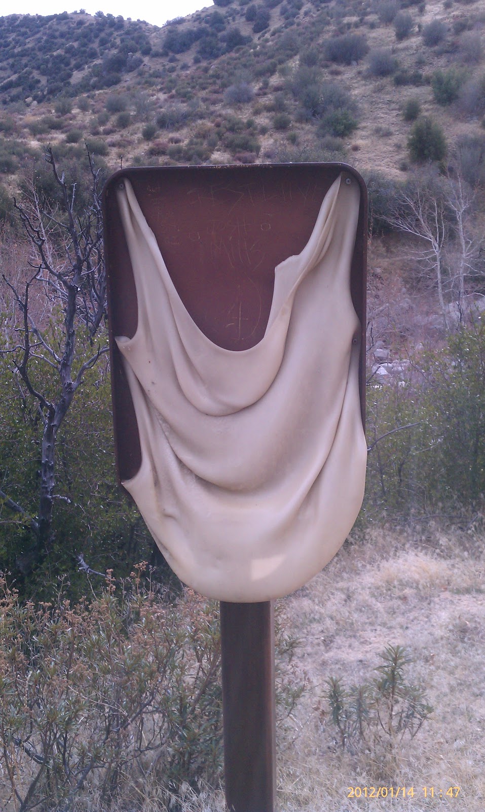
Hmmm....a melted sign from a forest fire I presume.

Deep Creek Hot Springs.

The arched bridge where the trail meets the Hesperia Aqueduct
which looks like a trail coming from the right edge of the picture.

Graffiti sample.

Colorful Graffiti on a PCT sign.

The gate was open to the dam and 4 wheelers were driving through the dam.